
Refining Tsunami Evacuation Behavior Modeling Using Human Mobility Data: Integrating Geography, Psychology, and Data Science
2026.07.23
Fiscal Year
FY 2025
April 2025 – March 2026
Principal Investigator
Shohei Nagata
Assistant Professor, International Research Institute of Disaster Science
Co-Investigators
Rei Saito
Assistant Professor, Cognitive Science, Graduate School of Information Sciences
Hiroki Adachi
Visiting Researcher, Graduate School of Environmental Studies / International Research Institute of Disaster Science
Research Keywords
Tsunami evacuation ; Human mobility data ; Evacuation behavior modeling ; Risk perception; GIS
1. Research Overview
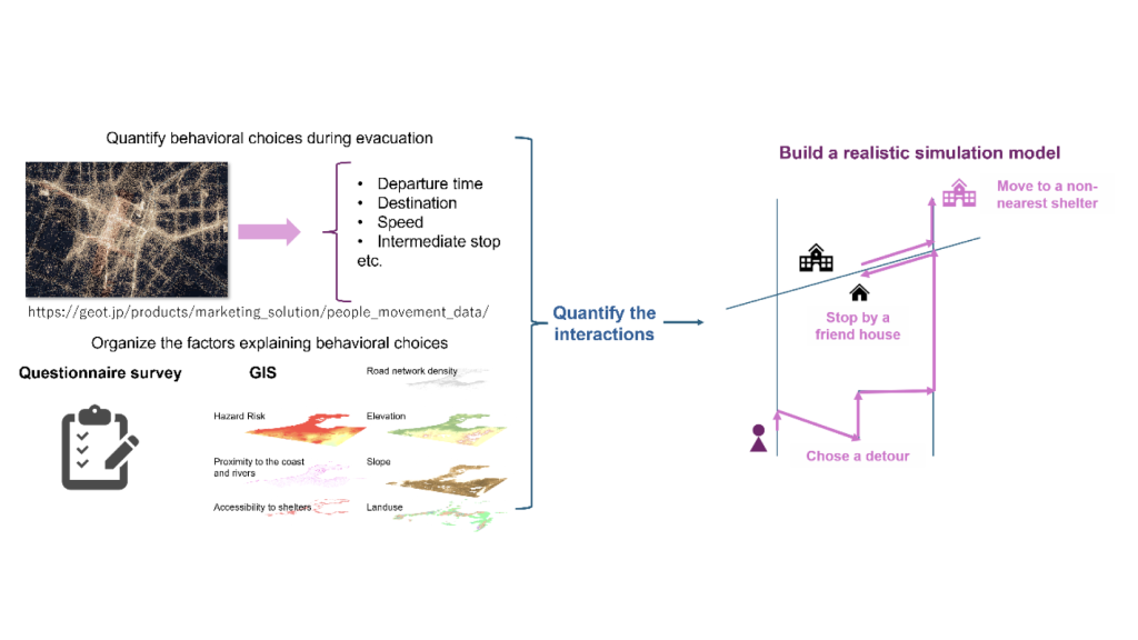
Understanding how people evacuate during disasters is essential for developing effective evacuation plans and simulation models. Conventional tsunami evacuation planning and simulation often rely on relatively simple assumptions, such as evacuees traveling to the nearest evacuation shelter via the shortest route. In reality, however, evacuation behavior is much more diverse. People may check on family members or friends, stop at intermediate locations, or evacuate to safe places other than designated shelters.
This study quantitatively analyzed individual tsunami evacuation behavior during the 2024 Noto Peninsula Earthquake using anonymized human mobility data collected through smartphone applications. Specifically, the analysis examined:
- Time elapsed before evacuation began after the earthquake,
- Travel distance and travel speed to safe locations,
- Types of evacuation destinations reached,
- Number of intermediate stops,
- Subsequent movements after reaching a safe location.
In addition, questionnaire surveys were conducted to collect information on evacuees’ demographic characteristics, risk perception, and psychological traits. Geographic Information System (GIS) analyses were also performed to characterize hazard risks, elevation, and proximity to evacuation shelters. These datasets were integrated to establish an analytical foundation for explaining diverse evacuation patterns.
Preliminary analyses conducted during FY2025 revealed that although many people located within tsunami risk zones began moving relatively soon after the earthquake, their destinations and travel routes varied considerably. Many evacuees traveled to shelters other than the nearest one or chose alternative safe locations. Numerous cases involved stopping at multiple locations before reaching safety, while others continued traveling even after arriving at an initial safe location. These findings demonstrate that actual evacuation behavior cannot be adequately represented by conventional simplified evacuation models.
The questionnaire survey further indicated that many participants recognized tsunami risk after experiencing strong ground shaking or after receiving tsunami warnings or advisories. However, relatively few respondents had taken sufficient disaster preparedness measures beforehand. Furthermore, many individuals evacuated together with family members or nearby people rather than acting alone. These observations suggest that understanding evacuation behavior requires consideration not only of individual risk perception but also of social relationships and levels of preparedness.
The preliminary analyses established an integrated analytical framework for understanding complex evacuation behavior in relation to individual cognition and the surrounding environment. Future work will identify characteristic evacuation behavior patterns and model how these patterns are associated with individual risk perception, psychological factors, and geographical conditions.
2. Significance of the Research and Future Prospects
The findings of this study provide fundamental knowledge for improving tsunami evacuation planning and simulation so that they better reflect actual human behavior.
Unlike conventional evacuation models that assume people travel directly to the nearest shelter along the shortest path, this research found that only a minority of evacuees actually behaved in this manner. Instead, a wide range of behaviors was observed, including intermediate stops, evacuation to non-designated safe locations, and additional movements after reaching safety. These insights offer more realistic evidence for planning shelter placement, evacuation guidance, information dissemination, and regional disaster management strategies.
Another distinctive feature of this research is its integration of multiple perspectives. In addition to identifying evacuation behavior patterns through human mobility analysis, the study combines questionnaire surveys on evacuees’ risk perception and psychological characteristics with geographical analyses such as hazard exposure and accessibility to evacuation shelters. This integrated approach provides a foundation for understanding not only where and how people moved, but also why they chose particular evacuation behaviors and which regional conditions constrained safe evacuation.
Building upon these findings, future research aims to predict likely evacuation patterns under future disaster scenarios and contribute to the design of more effective disaster risk reduction policies.
Furthermore, research outcomes supported by this project have already been presented at several international conferences. The project has also led to long-term overseas research visits by the principal investigator and expanded into international collaborative research. Future work will deepen the analysis of tsunami evacuation behavior during the Noto Peninsula Earthquake while comparing disaster cases from other countries to develop evacuation behavior models applicable to diverse disaster types and regional contexts.
3. Conclusion
This study analyzed individual tsunami evacuation behavior during the 2024 Noto Peninsula Earthquake using human mobility data obtained from smartphone applications. By quantifying evacuation patterns based on evacuation start time, travel distance and speed, destination, intermediate stops, and post-evacuation movements, the study confirmed that real evacuation behavior exhibits a wide variety of patterns rather than simple movement toward the nearest evacuation shelter.
By integrating questionnaire surveys and GIS-based geographical analyses, the research established an analytical framework for examining the relationships among evacuation behavior, individual cognition, psychological factors, and environmental conditions. The research outcomes achieved during FY2025 have already been presented at international conferences and have expanded into collaborative research with overseas research institutions.