
Cognitive Processes in Tsunami Evacuation Behavior Using VR and GIS
2026.09.25
Fiscal Year
FY 2025
April 2025 – March 2026
Principal Investigator
Kohei Sakaki
Assistant Professor, Center for Applied Cognitive Neuroscience
Co-Investigators
Daisuke Shiozaki
Seisa Dohto University
Yuichi Hashimoto
Hokkaido University
Naoki Miura
Tohoku Institute of Technology
Ayumi Takemoto
Institute of Development, Aging and Cancer
Yukihiro Shirahama
Graduate School of Medicine
Motoaki Sugiura
Institute of Development, Aging and Cancer / International Research Institute of Disaster Science
Research Keywords
Tsunami disaster prevention ; VR ; fMRI ; GIS
1. Research Overview
Since the Great East Japan Earthquake of March 11, 2011, awareness of the threat posed by massive earthquakes and the resulting tsunamis has grown in Japan, and a wide range of disaster prevention and mitigation measures have been discussed at every level, from the national government to individuals. Large tsunamis caused by a potential Nankai Trough megaquake or by megaquakes along the Japan and Kuril Trenches remain a concern, making disaster countermeasures an urgent task. In considering such measures, it is important, as Wisner et al. (2004) argued, to understand disaster risk in terms of vulnerability (social fragility) and hazard (the destructive force of nature).
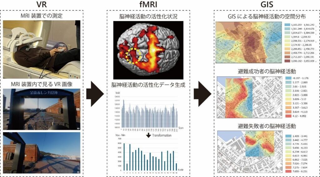
This study therefore aims to integrate approaches from geography and neuroscience to clarify decision-making in real-world evacuation behavior on the basis of brain activity and spatial information. We will also examine how the resulting knowledge can be linked to disaster prevention literacy education. However, because brain activity can be measured with fMRI (functional magnetic resonance imaging) only within an experimental facility, we study evacuation in a VR (virtual reality) space as an approximation of the real world.
The research methods are as follows. First, based on the simulated tsunami evacuation training system in VR space developed by Shiozaki and Hashimoto (2018), we build a new system compatible with fMRI. Next, participants carry out a simulated evacuation using this system while their brain activity data are collected. The brain activity measurement experiments were conducted after the research plan and experimental outline were submitted to and approved by the MRI Research Ethics Committee of the Smart-Aging Research Center, Tohoku University.
2. Significance of the Research and Future Prospects
This study is a pioneering attempt, even by international standards, to elucidate the mechanisms of spatial cognition and decision-making during disasters by integrating GIS-based evacuation behavior analysis—a geographical approach—with fMRI-based analysis of brain activity. Conventional geographical research has captured people’s environmental images and spatial behavior through questionnaires and interviews; by directly analyzing the underlying brain activity, this study makes it possible to capture the relationships among spatial conditions, cognitive and emotional responses, and evacuation behavior more objectively and comprehensively.
The results of this study provide a foundation for scientifically explaining how people perceive danger and choose evacuation routes during disasters. This will help identify the spatial and cognitive factors that hinder evacuation and contribute to developing evacuation environments that take into account road structures, landmarks, and signage. It will also lead to the development of VR-based disaster education grounded in human cognitive characteristics and decision-making processes, which is expected to promote rapid and appropriate evacuation during actual disasters. Furthermore, by feeding the findings back into regional disaster prevention plans and mitigation policies, the study will contribute to enhancing community resilience against large-scale disasters.
3. Conclusion
Since the Great East Japan Earthquake, disaster prevention and mitigation measures against massive earthquakes and tsunamis have become an urgent task. This study integrated geography and neuroscience to analyze decision-making during simulated tsunami evacuation in a VR space, using brain activity measured by fMRI and spatial behavior data. The results revealed widespread activity centered on the left superior occipital gyrus, the left fusiform gyrus, and the right precentral gyrus. In addition, local spatial partial correlations of the left superior occipital gyrus and the left fusiform gyrus were higher toward the wrong direction than toward the evacuation target direction, suggesting that participants who failed to evacuate may have been paying attention to the scenery and landmarks in the wrong direction. This study presents a new method for analyzing evacuation behavior that integrates VR, brain activity, and spatial information, and demonstrates its potential application to disaster prevention literacy education grounded in cognitive characteristics.